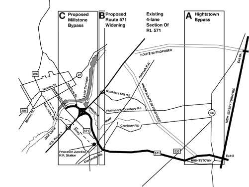
The Millstone Bypass will significantly impact many of the area's cultural and environmental resources. The construction of this federally-funded roadway --a 2.3 mile expanse with a 64-foot wide right-of-way and 54-foot paved width-- was designed with a four-lane cross section (see NJDOT project description and accompanying maps Appendix A & C). The Bypass, because of its geographic proximity to important historic sites, park lands, scenic rivers, and ecologically critical areas will have direct, indirect, and cumulative effects on the natural and human environment and the unique characteristics of the area. Those areas most impacted include: the Delaware & Raritan Canal State Park, the Washington Road Elms, the Millstone River stream corridor and surrounding wetlands and the entire region's air and water quality.
| Although the stated purpose of The Millstone Bypass is to remove traffic signals on Route 1, it is not simply an overpass. It is a 2.3 mile new roadway and part of a larger segmented project. The Bypass, in combination with the Hightstown Bypass (formerly an integral part of S-92) and the proposed widening of 571 in East and West Windsor, constitutes a major east-west arterial and link to the New Jersey Turnpike (see NJDOT descriptions of these projects in Appendix A). Not taking these interrelated connections into the traffic analysis gives faulty induced demand data. The segmentation of these projects is in violation of NEPA requirements and obscures the total social and cumulative environmental impacts. Mercer County is considered a severe non-attainment area under the Federal Clean Air Act. Currently, the State of New Jersey is in non-compliance with Clean Air Act requirements for reducing air pollution. The NJ State Development and Redevelopment Plan states: "with regard to transportation investment decisions, the State will need to significantly change the way it provides transportation control measures that will offset the growth in ozone precursor emissions resulting from the growth in vehicle miles of travel." | |
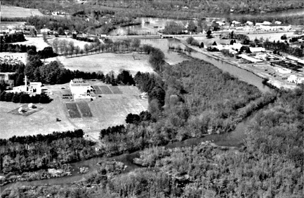 |
The Millstone Bypass as currently designed by NJDOT will be constructed on twenty-five acres of wetlands and undeveloped old growth woodlands on SRI David Sarnoff property adjacent to the Millstone River and Little Bear Brook. This project will impact the wetlands and woodlands known as Penns Woods. The Bypass will encroach upon the Millstone River stream corridor and proposes filling wetlands in this environmentally sensitive site. Policy 12 of the revised State Development and Redevelopment Plan, dated 6/25/97, reads: "Protect wetlands as a means of protecting water quality, controlling floods and ensuring habitat by controlling wetland filling and through watershed planning, local land use planning incentives, education and regulation." |
| View of the MillstoneRiver and Little Bear Brook with
Route 1 at the top and SRI Sarnoff Corporation on the left |
|
| This project will run parallel and in close proximity to the Delaware & Raritan Canal State Park, a property listed on the National Register of Historic Places. It is the most widely used recreational facility in the area for walking, jogging and boating. This park is the largest uninterrupted segment of the East Coast Greenbelt. The D & R Canal State Park is recognized in The NJ State Development and Redevelopment Plan as an Environmentally Sensitive Planning Area (PA5) and a Critical Environmental/Historic Site (CEHS). The Bypass will have negative visual, noise, storm drainage, and water quality impacts on the State Park. The negative noise and visual impacts constitute constructive use under Section 4(f) of the Department of Transportation Act of 1966. The Federal Highway Administration has determined constructive use occurs when: "the projected noise level increase attributable to the project substantially interferes with the use and enjoyment of a noise-sensitive facility...such as a historic site where a quiet setting is a generally recognized feature." | |
 |
 |
|
|
|
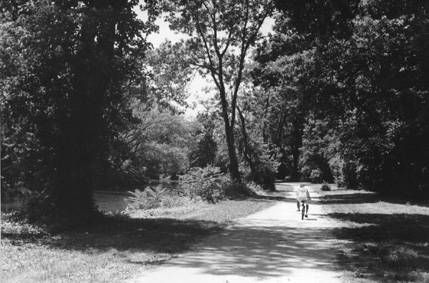
The three-quarter mile section of Washington Road (Mercer County
Road 571) between Route 1 and Faculty Road is one of the region's
most scenic and important features. Since 1806, when it was designated
as the entrance into Princeton, it has served as the eastern gateway
into the community. In 1920, after the completion of Lake Carnegie,
it was lined with American Elms, Ulmus Americana, by William Flemer,
the owner of Princeton Nurseries. The trees were planted on fifty-foot
centers and were a variety of elm known as Princeton, which had
been developed by the nursery after many trials to find a superior
American elm both in vigor and beauty. The now mature trees form
a majestic canopy across the road and provide a dynamic visual
perspective for residents and visitors. The elms, together with
the D & R Canal and Lake Carnegie, form an historic entrance
into The Princetons and Princeton University. It is a defining
aspect of the area, nationally and internationally recognized
as one of finest planned and planted gateways into a community.
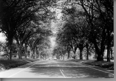 |
The Washington Road Elms are listed on the State and National Register of Historic Places. They are important to the area as an integral part of the Washington Road gateway into Princeton. They are also scientifically important. The elms are being studied as part of the United States Department of Agriculture's (USDA) ongoing research into Dutch Elm Disease (DED). In previous tests by that agency, the trees were found to be resistant to DED, which has destroyed over 100,000,000 American elms, a native species, and once the country's favorite shade tree. USDA is currently involved in further genetic studies of the Princeton Elms to discover what is responsible for this natural protection. This research has far-reaching horticultural importance. The current "final" design for the Millstone Bypass will destroy approximately one quarter of these trees. |
| The Washington Road Elm Allee |
There are prudent and feasible options to the NJDOT "final"
design for the Millstone Bypass. The West Windsor Township Master
Plan Update, adopted Sept. 3, 1986, is the source of several options.
The Plan strongly endorses a service road parallel to Route 1,
to act as an intra-municipal connection and an internal distributor
of local traffic from high density housing to office parks, future
Princeton University development, and Lawrence and Plainsboro
townships. (This portion of the West Windsor Master Plan Update
is attached as Appendix B).
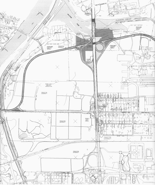
| To that end, and with these recommendations in mind, the following design alternative depicted in Appendix C, moves the Millstone Bypass away from the D & R Canal, and positions it close to Route 1 as a parallel frontage road, thus eliminating the negative impacts on the historic and environmentally sensitive area around the D & R Canal and the elms. This alignment also uses less Princeton University land. (Click on image to see expanded view.) | 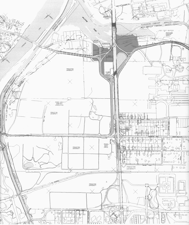 |
The same Master Plan also envisions a connector road linking
Vaughn Drive through Station Drive, joining Alexander Road with
Washington Road. It also shows an improved bridge over the Amtrak
lines joining Alexander Road to North Post Road with connections
via Clarksville-Grovers Mill Road to County Road 571. These are
shown as Appendix D. These designs (or similar ones to be
determined by a new West Windsor Master Plan), in conjunction
with a redesigned Washington Road-Route 1 intersection (see "cut-and-cover"
below), would help distribute traffic going east and west through
West Windsor. This is an alternative to the northern portion
of the proposed alignment of the Bypass. It would remove impacts
to the stream corridor and surrounding wetlands, by not paralleling
the Millstone River.
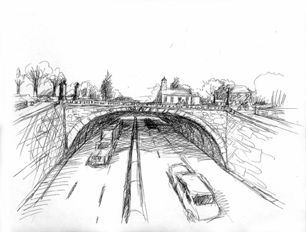 |
At the intersection of Route 1 and Washington Road, the use of a "cut-and-cover" design as recommended by FHWA to preserve and enhance historic properties and parks, (appendix E) would create a wide plaza in front of the historic Penns Neck Baptist Church with Route 1 traffic passing underneath. "Cut-and-cover" tunnels have saved historic properties in other parts of the country, and given local traffic, pedestrians and bicycles improved and safe access between communities. This concept could be accomplished by removing the hill that currently exists at Washington Road and creating a level grade for Route 1 from the Dinky overpass to Harrison Street. In combination with a frontage road, all the current traffic movements that exist for the Washington Road/Route 1 interchange would remain without signal lights on Route 1. |
These prudent and feasible options warrant serious analysis as a means of avoiding the significant impacts posed by the current "final" alignment on the adjacent natural and human environments.